How to Find Arco de las Peñitas in Fuerteventura: All You Need To Know
What to expect from hiking to the beautiful natural stone arch in FuerteventuraA natural arch worth trekking for
Arco de las Peñitas is a beautiful natural stone arch in Barranco de las Peñitas in the western/middle part of Fuerteventura.
It is not the easiest to find but when you do, it’s all worth it.
And the hike through the rocky, arid landscape is magnificent.
Read on in this travel guide to learn what to expect and how to reach Arco de las Peñitas.
Where to stay near Arco de las Peñitas in Fuerteventura:
- Value for money: Casa Princess Arminda (stay rurally and locally close to Betancuria).
Search for the best value accommodation near Betancuria here.
Table of contents
What to expect of Arco de las Peñitas
Barranco de las Peñitas is a ravine with rocky terrain and the landscape makes for a wonderful hike.
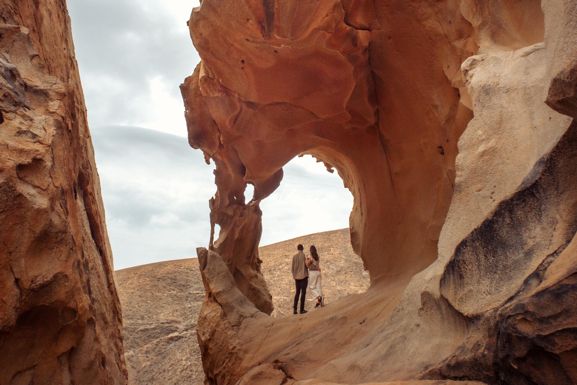
The highlight of this area is, in our opinion, Arco de las Peñitas which is hidden in the huge rock formations at the top of a hill.
The natural stone arch is a spectacular view point and you can take some beautiful photos from up there!
It’s definitely one of the best and most unique things to do in Fuerteventura.
However, there are no signs pointing you in the right direction and it’s not always obvious where to go. That’s why we made this travel guide.
And the trail to Arco de las Peñitas is very steep and uneven so remember to bring hiking shoes or sneakers you’re comfortable hiking in and be prepared to climb a few rocks.


Price
Visiting Arco de las Peñitas is free of charge!
Opening times
Arco de las Peñitas in Barranco de las Peñitas is open to everyone 24/7, but having said that, we advise you to go there in daylight as the terrain isn’t easy to tackle in the dark.
Required fitness level
It’s fairly easy walking around Barranco de las Peñitas but you need to be in decent shape to get all the way up to the arch.
Not necessarily in ridiculously good shape but the terrain is steep and uneven and you may have to climb some rocks.


How to get to Arco de las Peñitas
There are no signs or marked trails to get to Arco de las Peñitas so it’s not the easiest arch to find – but it’s not impossible!
The good thing is that the arch is actually located where it says “Arco de las Peñitas” on Google Maps and if you have downloaded an offline map, you can always navigate after that.
To get there, you can choose between a short hike or a long hike. Both routes are marked on the map below and described in detail further down.

Map
Arco de las Peñitas is located on the western central part of Fuerteventura in the Barranco de las Peñitas.
See the different ways to get there here or scroll down for a more detailed description.
Disclaimer: there isn’t a specific marked trail leading to the arch so the directions are approximate.

The short hike to Arco de las Peñitas
First, you should park your car at the off-road “aparcamiento” parking lot at the end of Camino Pajara (it’s free).
From there you should follow the trail heading north along the fences.
Then there are two ways to reach the arch which is hidden in the rock formations on top of a big hill:
- Follow the trail straight ahead until you have a huge pile of rocks to your right and then start to ascend the hill towards them (the blue route we painted on the map).
- Or go to the right towards the little white church (Ermita de la Peña), then turn left before reaching the church and go uphill towards the rock pile (the red route we painted on the map).
It takes about 30 minutes to an hour trekking all the way up to the arch.



The long hike to Arco de las Peñitas
If you want to explore more of the Barranco de las Peñitas, you can choose the long route from Vega de Río Palmas (the blue route we painted on the map).
Park your car at the “aparcamiento” parking lot on Camino San Sebastián/Camino Puerto de la Peña.
Follow the trail west through Barranco de las Peñitas past the water dam and the little white church (Ermita de la Peña). That will probably take around an hour.
Then turn right after the church and head towards the big pile of rocks on top of the hill which will take another 30 minutes or so.


Which hike should you choose?
We took the short and fastest hike to get to the arch. On the way up, we chose the first option (blue route) and on the way down, we went with the second option (red route) which was maybe less steep but a little longer – there isn’t a huge difference between the two.
The longer hike looks beautiful and if you want to see the (dried up) water dam up close and go through the ravine, this is the hike for you.
You can also see the water dam and Barranco de las Peñitas from “Mirador Las Peñitas” where you can park your car right by the viewpoint.
No matter which hike you choose, the trails will not be marked so the most important thing is that you head towards the gigantic rock formations.
You cannot see the arch from any of the routes before you’re really close so have faith that it will be there!
And be careful when climbing the rocks.
Also, you might encounter chipmunks, goats or ravens at the parking lot or along the trails but please don’t feed them.


When to visit Arco de las Peñitas
Arco de las Peñitas can be visited all year around.
We reached the arch at around 10.30 in the morning in January and were the first ones there. On the way back down we met a handful of happy hikers on their way up, but it was not crowded at all.
It was overcast the day we visited but it was actually nice since there’s no shade along the trails and the arch looked beautiful on the photos in the soft light without any sharp shadows.
Because of the rocky terrain and uneven surface up there, you might want to skip days with strong winds though.
If you go on a sunny day, we recommend hiking in the morning to get the most beautiful light on the arch and to minimise your exposure to the scorching sun.


Where to stay near Arco de las Peñitas
Betancuria – The central mountains of Fuerteventura
If you like hiking or don’t mind driving to the beach, staying in the central mountains (also known as the Betancuria Massif) in the western part of Fuerteventura can make sense.
Betancuria is known as the most beautiful town of the island and the mountains around here are stunning. The roads are very popular with road cyclists and the trails are great for hiking.
Staying in the central mountains also means you’ll be close to Arco de las Peñitas as well as Ajuy Caves and the black sand beach and several famous viewpoints.
Where to stay near Betancuria
- Value for money: Casa Princess Arminda.
Search for the best value accommodation near Betancuria here.
You can also look for the best and cheapest hotels in all of Fuerteventura here.

What to bring to Arco de las Peñitas
- Travel insurance (adlink). Never travel without it!
- A good camera – here’s a guide to the gear we use.
- Sunscreen (adlink) if you come on a sunny day. There’s no shade until at the top of the rocks.
- Hiking shoes or sturdy sneakers you’re comfortable trekking in.
- Water in a refillable bottle and snacks.
Minimise your impact
To minimise your impact, follow these guidelines:
- Bring your own drinking water in a refillable bottle.
- Avoid single-use plastics, including straws.
- Dispose of waste properly. There are no trash cans on the trails.
- Take only photos, leave only footprints. Let everything stay in its natural place. No stone-throwing or stacking.
- Be considerate of other visitors.
- Respect wildlife. Don’t feed the animals.

Thanks for reading
Thank you for reading our travel guide to Arco de las Peñitas. We hope it has been useful!
What do you think about Arco de las Peñitas and the landscapes in Fuerteventura?
If you’ve been to the beautiful natural arch it would be awesome to hear how your experience was.
And if you haven’t been yet, please don’t hesitate to ask us anything. We’re glad to help.


Our favourite travel resources:
- Booking.com for cheap hotels.
- Momondo for the best flight deals.
- SafetyWing for travel insurance. We also like World Nomads and True Traveller. All three compared here.
Our camera gear:
- Panasonic GH5. Used for all of our photos and videos.
- DJI Mavic 2 Pro. Best drone out there!
- Sirui Tripod. Lightweight and strong.
- See all of our camera gear here.



 Book cheap hotels
  Find the best flight deals
  Nomad insurance
  Our Camera Gear
 Our Packing List
Thanks for the great map. Not sure if I would’ve found the arc without it. I did the long hike. Where it almost went wrong is where the green and red paths meet up. You just need to keep walking on the ‘green’ path until you get to the ruins of a stacked stone building. That’s where you turn right to join the red path (it takes around 30min with photo stops from the parking in Vega de Rio Palmas until the ruined shed/house).
You’re very welcome and thanks for sharing your experience!
Hi, I’ve just read about Fuerteventura and Arco de las Penitas and I got question if I could…
How safe is the trail for walking with children 8 years old, please? Is it a difficult trail? We’re hiking but aren’t very experienced with high or difficult trails. We’re taking trainers, not enough space for additional trekking shoes… Thanks in advance for your suggestions 😊
Hi Magdalena, once you know the way, the trail itself is neither very long nor difficult. Dedicated hiking shoes shouldn’t be needed. Just take it slow and you will most likely be fine! Have fun 😊