Where the road ends
Follow Koh Lanta’s west-coast road south until it stops, and you will be at the national park.
Mu Ko Lanta National Park covers the whole southern tip of Koh Lanta, plus a lot of sea and islands further out.
The part you can drive to is a car park, a visitor centre, a 2 km nature trail, a beach and a lighthouse. You might also meet some dusky leaf monkeys.
We first got to know Koh Lanta in 2018 and came back for a few weeks in February 2026 with our two small children.
Alex scootered down to the park alone one morning, hiked the trail and climbed up to the lighthouse. In this guide, we share what the trail is like, how to get there, what it costs and what else there is to see once you’re in.
Where to stay near Koh Lanta National Park:
- Budget: Klong Jark Bungalow – Some of the cheapest bungalows on Koh Lanta, right on the beach and a short ride from the park gate.
- Value for money: Anda Lanta Resort – Large family rooms and a pool in a quiet corner of Klong Jark.
- Luxury: Pimalai Resort & Spa – Koh Lanta’s most beautiful (and most expensive) resort, at Kantiang Bay.
Search for the best hotels on Koh Lanta here (adlink).
Table of contents
- What to expect at Koh Lanta National Park
- How to get to Koh Lanta National Park
- Koh Lanta National Park entrance fee
- The Laem Tanod nature trail
- The beach at Koh Lanta National Park
- The dusky leaf monkeys
- The Koh Lanta lighthouse
- Visitor centre, campsite and facilities
- Visiting Koh Lanta National Park with kids
- What to bring
- Tips for visiting Koh Lanta National Park


Advertisement
What to expect at Koh Lanta National Park
On Koh Lanta itself, the park is the Laem Tanod headland at the southern tip of the island, and everything is within a few hundred metres of the car park.
- Location: The southern end of the west-coast road, past Kantiang Bay, Klong Jark and Bamboo Beach.
- Entrance fee: 200 baht (~ 5.5 EUR / 6 USD) per foreign adult and 100 baht per child, plus 20 baht for a scooter or 30 baht for a car. Children under 3 go free. Bring cash.
- Getting to the beach: You don’t have to hike to reach the beach. It’s a 5-minute walk from the car park on a paved path.
- The nature trail: A 2 km (~ 1.2 miles) horseshoe through the forest from the car park to the beach. The park says about an hour. Alex’s walk took 45 minutes.
- Difficulty: Moderate. The first 400 metres are steep, with roots, loose earth and ropes to hold on to. After that it’s still quite hilly, and Alex reckons it would be hard for most younger kids and older visitors.
- Trail surface: Rough concrete steps, then dirt and roots, then paved stone slabs and tiles through the forest and stone stairs down to the beach.
- Shoes: Something with grip. The steep bit is loose and the park’s own signs call the route slippery.
- Shade: The whole trail is under the trees. The lighthouse headland is in full sun, and the beach only has shade at the back.
- Suitable for children: The trail is not suitable for most children, as it stays hilly all the way around. The beach, the swings, the monkeys and the short walk to the viewpoint from the beach side definitely are, though (more below).
- Facilities: Toilets, a drinks and fruit kiosk by the beach, a restaurant serving meals (9:00-16:00), a visitor centre, a campsite and free wifi according to the map board.
- Swimming: Yes, at the sand beach, inside the buoy line. Not at the rocky beach below the lighthouse.
Map of Koh Lanta National Park
The park’s own area map is at the car park and again down at the beach.
The car park, the headquarters and the visitor centre are on the left of the map.
The nature trail leaves from the top end of the scooter parking area, loops through the forest on the hill and comes out at the beach.
From the signpost on the sand, it’s 200 metres to the viewpoint, 300 metres to the lighthouse and 200 metres to the rocky Hin Ngam Beach on the far side of the headland.
The map also gives walking times: 5 minutes from the car park to the sand beach, 10-15 minutes up to the lighthouse and 15-20 minutes to the trail viewpoint if you go by the beach instead of over the hill.


How to get to Koh Lanta National Park
The only way in is the west-coast road, all the way to the end.
From Klong Nin southwards, the road gets hilly and winding, with some steep climbs and descents between Kantiang Bay, Klong Jark and Bamboo Beach.
Take it steady on a scooter, especially on the way down.
Alex rented a scooter for the day for 250 baht (~ 7 EUR / 8 USD) and rode down from Lanta Secret House (adlink) on Long Beach, which took about half an hour.
The entrance fee and the parking fee are paid at the gate, and the scooter parking area is right at the foot of the trail.
The hill back up out of the park is steep, but it should be fine for most scooters.
If you’d rather not ride the hills yourself, the island’s taxis and pick-up trucks all know the way. Ask them to wait or agree on a pick-up time.
Bamboo Beach is the last beach before the park gate, and the last one you can visit without paying the park fee.
On the way back, Alex stopped at Sam Pee Nong Family Seafood, a restaurant above it with a view down the whole bay.


Our recommendations for the best places to stay on Koh Lanta from budget to luxury
Read moreKoh Lanta National Park entrance fee
The fees are on the board at the gate. In 2026, foreign visitors pay 200 baht (~ 5.5 EUR / 6 USD) per adult and 100 baht per child, where a child is 3-14 years old or under 140 cm. Children under 3 are free.
Parking costs extra: 20 baht for a scooter, 30 baht for a car.
If you camp in the park, one ticket covers a stay of up to 5 days.
However, it’s not valid for Koh Rok, Koh Ngai, Koh Haa or the Hin Daeng and Hin Muang dive sites, even though they belong to the same national park. Boat and dive trips to those come with a separate fee.
The sign next to the fee board bans single-use plastics in the park, such as water bottles with a plastic seal, straws, bags, plastic cutlery and foam boxes. Bring a refillable bottle.
The Laem Tanod nature trail
The park calls it “LaemTanod Forest Wonders”, and it’s a 2 km horseshoe over the forested hill between the car park and the beach. If you just want the beach, skip the trail and follow the paved path from the car park instead. It takes about 5 minutes.
It’s a proper trail, not long or dangerous, but you need your hands on the first stretch, and flip-flops are likely a bad idea.
The trailhead
The trail starts at the top end of the scooter parking area, where a flight of rough concrete steps climbs into the forest beside a big pale-trunked tree.
Two boards stand here (the area map and the trailhead board with the loop drawn on it), along with a pair of warning signs you’ll see again: “Danger!! Slippery area” and a reminder to beware of poisonous wildlife and keep to the path.
There’s an emergency number on the sign too, and more of them on red-and-white posts along the way.
There were a lot of people and scooters at the car park when Alex arrived around 11:00. Most of them seemed to head straight for the beach, though.


The steep first 400 metres
The park’s map board says the first 400 metres are steep and quite difficult, and that’s fair.
The path is eroded dirt with exposed roots and loose earth, climbing hard through the forest, and ropes are strung along the worst stretches to pull yourself up on. In places, there’s a rustic railing of branches.
It was dry-season dust when Alex was there. After rain, we imagine it’s a lot harder.
Between the climbs, the trail levels out past huge buttressed trunks and hanging lianas.

The giant tree
About 10 minutes in, a log railing and an information board mark a giant Thai crape myrtle (Lagerstroemia calyculata) with a smooth, pale trunk going straight up through the canopy.
The board says the species grows to 30 metres, and that Thai families traditionally plant one at home for wealth and strength.
There are more information boards about the plants along the way, and a dusky leaf monkey drawn on the trailhead board.
Alex didn’t see any monkeys on the trail itself, though, only at the beach.


The paved stretch
Once the climbing is done, the dirt gives way to a paved path of stone slabs and tiles that winds on through the forest, over a little cobbled footbridge and up and down a few more small hills.
It’s still hilly, but it’s walking rather than scrambling, and now and then the canopy opens for a glimpse of blue sea and an island on the horizon.


The viewpoint
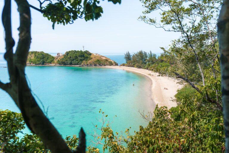
Just over half an hour in, a stone stairway drops towards a gap in the trees.
This is the viewpoint.
The view is partly hidden by leaves, so move around a bit for the best angle. The water is clear enough to see the reef patches from here.
If you only want this view, you don’t have to do the loop.
Going by the beach instead, the map gives it 15-20 minutes from the car park, on the paved stairs rather than the steep dirt. Much easier, in other words.


Down to the beach
From the viewpoint, the stone stairs continue down through the forest and come out behind the beach, next to a white building and a wooden “Nature Trail” sign pointing back the way you came.
Alex took 45 minutes, photo stops included. The park’s estimate of an hour is fair at a normal pace.
It’s a loop, so you don’t walk back over the hill. The car park is a 5-minute walk from the beach along the paved path past the kiosk, the campsite and the visitor centre.
The beach at Koh Lanta National Park
The park map just calls it Sand Beach.
It’s a curve of pale sand running from the campsite to the foot of the lighthouse headland, with calm, shallow water and a swimming area marked by a line of buoys.
Casuarina and pandanus trees give shade along the back, and a couple of driftwood swings hang from the branches over the sand.
Even on a busy high-season day, there was plenty of empty sand between the swimmers and sunbathers.


Flags, jellyfish and the rocky beach
Where the trail meets the beach, a board explains the beach flag system: red for high hazard, yellow for medium, green for calm conditions and purple for marine pests such as jellyfish and stingrays.
A yellow flag was flying on the day Alex visited, with a flat, calm sea below it.
There’s a first-aid board for jellyfish stings next to it.
The park says stings here are rare, but for a box-jellyfish sting, call 1669, pour vinegar over the wound for at least 30 seconds, and don’t use fresh water or rub it.
On the other side of the headland is the rocky Hin Ngam Beach. Signs there say no swimming and no drones.


The kiosk and the restaurant
Right by the entrance to the beach, there’s a small kiosk selling cold drinks, coffee, fresh fruit, smoothies and ice cream from 9:00 to 17:00, with a few shaded seats.
For a meal, the park map marks a restaurant up by the headquarters, a 2-minute walk from the car park, open 9:00-16:00 according to the camping board.


The dusky leaf monkeys
Dusky leaf monkeys (also called spectacled langurs, for the white rings around their eyes) live in the casuarinas and palms between the beach and the campsite.
Alex saw a whole group of them a few metres above a crowd of excited beachgoers.
The monkeys are grey, calm and generally not bothered by people. They sat chewing leaves, hung from branches by one arm and looked down at the phones.
One adult was holding a baby with the bright orange coat that dusky leaf monkeys are born with.
Don’t feed them, however close they come. They’re wild animals (and should remain so!).


The Koh Lanta lighthouse
From the signpost at the beach, it’s 300 metres to the lighthouse, and most of that is uphill.
A bare, sandy path climbs the grassy headland from the end of the beach.
It’s very short, but steep right at the start and a bit eroded in places, and a park sign warns of unstable rock and tells you to stay off the cliffs.
The map board gives it 10-15 minutes.
At the top stands the white lighthouse tower on a railed platform, with the sea on three sides.

A lighthouse named by a king
According to the board at the foot of the hill, the original Phatchotiwachirapha Lighthouse was built here in 1927 and given its name by King Prajadhipok (Rama VII).
When the old tower became too damaged to repair, a new one was built next to it and opened on 23 March 1971.
It used acetylene gas lamps until 1990, when it switched to solar power, and it still flashes the same signal: three white flashes every 15 seconds.
The board puts the light 31 metres above the sea and says it can be seen from 12 miles out. It belongs to the Royal Thai Navy’s Hydrographic Department, and you can’t go inside.


The views from the headland
Look back the way you came, and the whole sand beach curves below.
From the right spot on the path, you see both bays at once, with a narrow neck of sand between them and turquoise water on either side.
Out to sea, the headland ends in a ridge of jagged dark and white rock with a small islet off the point, and longtail boats pass below on their way around the island.
Straight down from the cliff edge, the water is clear enough to see the rocks on the bottom.
Mind the edge. The rock is loose (the signs say so), and there’s no railing anywhere except at the tower.


Visitor centre, campsite and facilities
The national park visitor centre is near the car park, next to the headquarters.
It’s nothing special, though, just a small room with a 3D model of the headland and its bays and some photos of snorkelling sites.
Camping in Koh Lanta National Park
You can sleep in the park. Rows of dome tents stand on the lawn under the palms and casuarinas right behind the beach, with the monkeys in the trees above them.
The price board at the visitor centre gives the fees in 2026 as 80 baht (~ 2 EUR / 2.5 USD) per person to pitch your own tent, or 450 baht (~ 12 EUR / 14 USD) a night for a park tent sleeping three, bedding not included.
A pillow, a sleeping pad and a sleeping bag can be hired for 10, 20 and 30 baht a night.
There are power outlets (bring your own plugs) and toilets. The restaurant is open from 9:00 to 16:00, and there is a mobile signal on the AIS network.
Overnight stays are capped at 240 people a day, and camping is arranged with the visitor centre staff during their hours, 8:30-16:30.


Visiting Koh Lanta National Park with kids
We didn’t bring ours. Adrian was 2.5 and Zoe was 6 months, and Alex went down alone while the rest had a slow morning at the hotel.
The steep first 400 metres of the nature trail, with ropes and loose earth, are no place for a toddler who insists on walking, and a stroller is out of the question anywhere on the hill.
Beyond that, the loop stays hilly, so it’s hard going for most children and older people too.
From the car park, it’s a 5-minute walk on a paved path to the sand, where you get calm, shallow water inside the buoys, swings, shade, a kiosk with ice cream and monkeys in the trees above you.
Bigger kids can add the walk up to the viewpoint from the beach end, on stone stairs rather than the rough dirt, and the lighthouse path, which is a sandy slope with an unfenced cliff at the top. Just keep little ones close up there.
Entry is 100 baht (~ 2.5 EUR / 3 USD) for ages 3-14 and free under 3.

What to bring
- Cash for the entrance fee, the parking and the kiosk.
- A refillable water bottle.
- Shoes with grip for the trail. Sneakers or trail sandals, not flip-flops.
- Sunscreen and a hat for the beach and the lighthouse headland, which has no shade at all.
- Mosquito repellent for the forest.
- Swimwear and a towel, because the beach is right there at the end of the trail.
- A camera with a bit of zoom for the monkeys. Here’s our guide to lightweight photography gear for high-quality travel content.
Tips for visiting Koh Lanta National Park
- Walk the loop from the car park, not from the beach. That way you do the steep part going up, with the ropes to help, and finish on the sand with a cold drink.
- Do the trail first and the lighthouse after. Both are hot work, and you can cool off at the beach in between.
- Check the flag before you swim, and stay inside the buoy line. Purple means jellyfish.
- Look up in the trees behind the beach and around the campsite for the leaf monkeys. Or just look for people taking photos of trees.
- Combine it with the rest of the south. Bamboo Beach, Klong Jark and Kantiang Bay are all on the way, so it makes sense to plan a meal or some extra beach time down here.
- Leave the drone at home. The signs here say no drones.
- Pick up an eSIM. There’s a mobile signal in the park, and it’s useful on a trail where you may be the only person. We’ve previously used Airalo (adlink) with great success.
- Don’t forget travel insurance. We compare the best travel insurance for digital nomads and long-term travellers here.
- Read our full guide to Koh Lanta for the beaches, the towns, the food and everything else on the island.
Everything you need to know about Koh Lanta in Thailand, including the best beaches, towns to see, what to do and our best tips
Read moreSustainable travel tips
The park already bans single-use plastics. A few more things that help:
- Bring a refillable bottle and fill it before you set off.
- Take your rubbish back with you.
- Stay on the path and off the cliffs, for the plants’ sake as well as yours.
- Don’t feed the monkeys, and keep your distance from the babies.
- Use reef-safe sunscreen if you swim. The reef patches are right there under the buoy line.
Thanks for reading our guide to Koh Lanta National Park
We hope it helps you plan a trip to the park.
For the rest of the island, have a look at our Koh Lanta travel guide and our guide to where to stay on Koh Lanta.
Have you walked the trail or camped by the beach? Let us know in the comments below.

Our favourite travel resources:
- Booking.com for hotels and apartments.
- Momondo for the best flight deals.
- AirHelp for flight delay compensation.
- GetYourGuide for great tours everywhere.
- Airalo for reliable eSIM.
- Discover Cars for transparent car hire.
- SafetyWing for travel insurance. We also like True Traveller. Compared here.

Where to Stay on Koh Kradan: The Best Hotels from Budget to Luxury
Our recommendations for the best places to stay on Koh Kradan from budget to luxury
-
Koh Kradan Travel Guide: 8 Best Things to Do
Everything you need to know, including what to do, when to visit and how to get there
-
Where to Stay on Koh Mook: Best Hotels & Areas
Our recommendations for the best places to stay, from budget bungalows to the island's iconic luxury resort